
Wednesday, January 25, 2012
Wednesday Weather Whys: Cold Air Damming
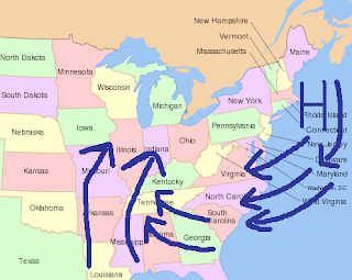
One of the most complex weather patterns in western North Carolina is cold air damming. This occurs when high pressure centers itself just offshore or onshore the coast of New England. Wind comes out of the northeast and banks itself up against the mountains. Cold air is transported from the Atlantic Ocean and from the north over the Carolinas. During many events, temperatures struggle to reach the mid-30s during the winter. In some cases, this can be the ingredient needed for an ice storm in western North Carolina. Low pressure rides up from the Gulf of Mexico and sends warm moist air up and over the cold air. The temperatures aloft are to warm for snow; however, the temperature at the ground is below freezing. This results in freezing rain or sleet falling from the clouds.
Subscribe to:
Post Comments (Atom)
No comments:
Post a Comment