After a few nice spring like days, our next system will begin approaching from the west. Right now, models are suggesting that the weather Thursday will feature cloudy skies and scattered light showers. The next big system appears to push into the area over the weekend. A lot of uncertainty accompanies this system; however, it appears very heavy rain could push over the area. We will keep you updated, but below is your three day forecast:
TUESDAY: Sunny with highs in the mid 60s and lows in the low 40s.
WEDNESDAY: Partly Cloudy with showers overnight. Highs in the mid 60s and lows in the upper 40s.
THURSDAY: 40% chance of light showers. Light accumulations. Highs in the mid 60s and lows in the upper 30s.
Monday, January 30, 2012


Thursday, January 26, 2012
Possible Strong to Severe Storms This Evening, Tonight

The Storm Prediction Center in Norman Oklahoma has the foothills of North Carolina in a slight risk for severe storms today. According to the SPC, the slight risk runs right through eastern Burke County through western Lincoln County. The other areas west of Hickory are in the threat for mainly non-severe storms; however, no guarantees can be made. Severe storms can occur outside of the threat area, and with the threat area so close, everyone needs to be sure to be ready for severe weather tonight. The strongest storms look to penetrate through the area between 9:00 p.m. Thursday and 1:00 a.m. Friday. These storms have a chance to produce very strong winds, small hail, heavy rain, lightning, and a slight chance of a tornado. Be sure to have your NOAA Weather Alert radio on tonight and keep in touch with the latest information from the NWS via television, radio, and/or the internet.
For more information, visit the Storm Prediction Page: http://spc.noaa.gov/products/outlook/day1otlk.html
Wednesday, January 25, 2012
No Real Cool Down Expected
Looking into the long range today, no real cool down is seen at least for next week. A front will push showers and thunderstorms through the area late Thursday evening and early Friday morning. Some areas could see over a half inch of rain from the system. The weekend will clear out nice with temperatures in the 50s right through the mid-week. Temperatures following this period could rise a little with another ridge building into the area. Its not looking to good for snow lovers through the first weeks of February, but you never know what the last couple weeks of February and the first couple weeks of March will have for the foothills of North Carolina.
Wednesday Weather Whys: Cold Air Damming
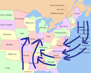
One of the most complex weather patterns in western North Carolina is cold air damming. This occurs when high pressure centers itself just offshore or onshore the coast of New England. Wind comes out of the northeast and banks itself up against the mountains. Cold air is transported from the Atlantic Ocean and from the north over the Carolinas. During many events, temperatures struggle to reach the mid-30s during the winter. In some cases, this can be the ingredient needed for an ice storm in western North Carolina. Low pressure rides up from the Gulf of Mexico and sends warm moist air up and over the cold air. The temperatures aloft are to warm for snow; however, the temperature at the ground is below freezing. This results in freezing rain or sleet falling from the clouds.

Wednesday, January 18, 2012
Wednesday Weather Whys: Mountain Upslope Snow
Many people ask me why the mountains receive more snow than we do here on the east side of the mountains. One of the reasons why the mountains receive more snow is due to uplsope snow behind low pressure systems. Upslope snow occurs when the wind blows out of the northwest. While most of us in the foothills remain dry and sunny with very cold temperatures, the mountains have very heavy snow. The winds hit the mountains and move upward, causing clouds to form and snow eventually develops. A few inches of snow can fall in a short amount of time, and the snow is usually accompanied with gusty winds. Every so often, we may see flurries outside of the mountains, and in very rare cases, snow can accumulate here in the foothills of North Carolina.
Sunday, January 15, 2012
Showers Possible Tuesday, Warm Up Coming Soon
Monday will feature increasing clouds with highs in the low 50s. A weak system will push through the area on Tuesday, bring showers and a slight chance of a thunderstorm. Highs Tuesday will be in the upper 50s. Lows Monday and Tuesday will be in the mid 30s. Wednesday and Thursday will be sunny and cool with highs in the mid to upper 40s and lows in the mid to upper 20s. A modest warm up will start next weekend, with temperatures Friday, Saturday, and Sunday increasing from the mid 50s Friday to the mid 60s Sunday.
Wednesday, January 11, 2012
Wednesday Weather Whys: Snow Above Freezing
A common question is how can it snow when the temperature is above freezing? This is a very complicated subject and a difficult question to answer. The concept is the wet bulb temperature. Basically, the air above the ground must be below 32 degrees; however, there is a very shallow layer of temperature at the ground above freezing. The air is not 100% saturated with moisture, so some of the snow is being evaporated into the air before it hits the ground. This evaporation is causing the air to cool, and the end result is the air temperature begins to cool. Eventually, the temperature will drop to freezing or the snow will change over to rain.
Subscribe to:
Posts (Atom)